Ireland
| Native name: Éire | |
 True colour image of Ireland, captured by a NASA satellite on 4 January 2003, with the Atlantic Ocean to the west and the Irish Sea to the east. | |
| Geography | |
|---|---|
 | |
| Location | Western Europe |
| Area | 81,638.1 km² (31,520.6 sq mi) [1] (20th) |
| Coastline | 3,700 km (2,300 mi) |
| Highest point | Carrauntoohil (1,041 m (3,414 ft)) |
| Country | |
| Largest city | Dublin |
| | |
| Constituent country | Northern Ireland |
| Largest city | Belfast |
| Demographics | |
| Population | 5,981,448 (as of 2006) |
| Density | 71 people/km2 |
| Ethnic groups | Irish, Ulster Scots |
Ireland (pronounced /ˈaɪɚlənd/, locally [ˈaɾlənd]; Irish: Éire, Ulster Scots: Airlann) is the third largest island in Europe, and the twentieth-largest island in the world. It lies to the north-west of continental Europe and to the west of Great Britain. Politically, the state Ireland, sometimes described as the Republic of Ireland,[2] covers five-sixths of the island, with Northern Ireland, part of the United Kingdom, covering the remainder in the north-east.
The first settlements in Ireland date from 8000 BC. By 200 BC Celtic migration and influence had come to dominate the island. Relatively small scale settlement by both the Vikings and Normans in the Middle Ages gave way to complete English domination by the 1600s. Protestant English rule resulted in the marginalisation of the Catholic majority. A famine in the mid-1800s caused deaths and emigration. Following a war of independence, Ireland was split into: the independent Irish Free State and Northern Ireland, which remains a part of the United Kingdom. The Free State left the Commonwealth to become a Republic in 1949. In 1973 both parts of Ireland joined the European Economic Community. Sectarian conflict in Northern Ireland led to much unrest from the late 1960s until the 1990s, which subsided following a peace deal in 1998.
The population of the island is slightly under 6 million (2006), with 4.2 million in the Republic of Ireland[3] and an estimated almost 1.75 million in Northern Ireland.[4] This is a significant increase from a modern historical low in the 1960s, but still much lower than the peak population of over 8 million in the early 19th century, prior to the Great Famine.[5]
The name Ireland derives from the name of the Celtic goddess Ériu (in modern Irish, Éire) with the addition of the Germanic word land. Most other western European names for Ireland, such as French Irlande, derive from the same source.[6]
Contents1 Political geography
|
Political geography

- Further information: for the political history of the island, see History of Ireland; for other political institutions, see Politics of Ireland and Demography and politics of Northern Ireland
The island of Ireland is occupied by two political entities:
- Ireland (also sometimes 'Republic of Ireland', for disambigation purposes), a sovereign country, covers five-sixths of the island. Its capital is Dublin.
- Northern Ireland, part of the United Kingdom of Great Britain and Northern Ireland, covers the remaining sixth. Its capital is Belfast.
All-island traditional subdivisions
Traditionally, the island of Ireland is subdivided into four provinces: Connacht, Leinster, Munster and Ulster; and, in a system developed between the 13th and 17th centuries, thirty-two counties.[7] Twenty-six of the counties are in the Republic of Ireland, and six counties (all in Ulster) are in Northern Ireland. "Ulster" is often used as a synonym for Northern Ireland, although Ulster and Northern Ireland are neither synonymous nor co-extensive, according to boundaries established in the early modern period, as three counties of Ulster (Cavan, Donegal and Monaghan) are part of the Republic. Counties Dublin, Cork, Limerick, Galway, Waterford and Tipperary have been broken up into smaller administrative areas, but are still considered by Ordnance Survey Ireland to be official counties. The counties in Northern Ireland are no longer used for local government, although their traditional boundaries are still used in sports (such as Gaelic games)[8] and in some other cultural, ceremonial or tourism contexts.[9]

| Province | Population[10] | Area (km²) | Largest city |
|---|---|---|---|
| 504,121 | 17,713 | Galway | |
| 2,295,123 | 19,774 | Dublin | |
| 1,173,340 | 24,608 | Cork | |
| 1,993,918 | 24,481 | Belfast |
All-island institutions
The island operates as a single entity in a number of areas which transcend constitutional divisions. With a few notable exceptions, the island operates as a single unit in all major religious denominations and in many economic fields despite using two different currencies. There are also significant all-island dimensions to sports such as hurling, gaelic football, rugby, golf, cricket and hockey.
An exception to this is soccer: following Partition, the (previously all-island) Irish Football Association retained control of soccer only in Northern Ireland, with a separate Football Association of Ireland being formed for the remainder of the island. The creation of an all-island soccer league and a single international team (as is the case for rugby union) has been publicly touted by various prominent figures on the island in recent years, such as Irish government minister Dermot Ahern.[11] More recently, FAI chief executive John Delaney believes there will be an all-Ireland league, but not before 2012, as a contract involving the Eircom League and the FAI runs to 2011.[12] An all-Ireland club cup competition, the Setanta Cup, was created in 2005.
All major religious bodies are organised on an all-Ireland basis, such as the Roman Catholic Church, the Methodist Church in Ireland, the Anglican Church of Ireland and the Presbyterian Church in Ireland. Some trade unions are also organised on an all-island basis and associated with the Irish Congress of Trades Unions (ICTU) in Dublin, while others in Northern Ireland are affiliated with the Trades Union Congress (TUC) in the United Kingdom, and some affiliate to both—although such unions may organise in both parts of the island as well as in Great Britain. The Union of Students in Ireland (USI) organises jointly in Northern Ireland with the National Union of Students of the United Kingdom (NUS), under the name NUS-USI.
Strand 2 of the Belfast Agreement provides for all-Ireland co-operation in various guises. For example, a North-South Ministerial Council was established as a forum in which ministers from the Irish government and the Northern Ireland Executive can discuss matters of mutual concern and formulate all-Ireland policies in twelve "areas of co-operation", such as agriculture, the environment and transport. Six of these policy areas have been provided with implementation bodies, an example of which is the Food Safety Promotion Board. Tourism marketing is also managed on an all-Ireland basis, by Tourism Ireland.
Two political parties, Sinn Féin and the Irish Green Party, contest elections and hold legislative seats in both jurisdictions. The largest party in the Republic of Ireland, Fianna Fáil, registered with the Electoral Commission in Northern Ireland, and has considered extending its organisation into Northern Ireland, perhaps via a merger with another political party, the Social Democratic and Labour Party (SDLP).[13]
An increasingly large amount of commercial activity operates on an all-Ireland basis, a development that is in part facilitated by the two jurisdictions' shared membership of the European Union. There have been calls for the creation of an "all-island economy" from members of the business community and policy-makers on both sides of the border, so as to benefit from economies of scale and boost competitiveness in both jurisdictions.[14] This is a stated aim of the Irish government and nationalist political parties in the Northern Ireland Assembly.[15] One commercial area in which the island already operates largely as a single entity is the electricity market.[16] and there are plans for the creation of an all-island gas market.[17]
17 March is celebrated throughout the island of Ireland as St. Patrick's Day.
Physical geography

A ring of coastal mountains surrounds low central plains. The highest peak is Carrauntoohil (Irish: Corrán Tuathail) in County Kerry, which is 1,041 m (3,414 ft).[18][19] The River Shannon, at 386 km (240 miles) is the longest river in Ireland.[20][21] The island's lush vegetation, a product of its mild climate and frequent rainfall, earns it the sobriquet "Emerald Isle". The island's area is 84,412 km²[18] (32,591 square miles).
Ireland's least arable land lies in the south-western and western counties.[citation needed] These areas are largely mountainous and rocky, with green panoramic vistas.
Climate
Overall, Ireland has a mild, but changeable, Oceanic climate with few extremes. The warmest recorded air temperature was 33.3 °C (91.94 °F) at Kilkenny Castle, County Kilkenny on 26 June 1887, where as the lowest recorded temperature was −19.1 °C (−2.38 °F) at Markree Castle, County Sligo on 16 January 1881.[22]
Other statistics show that the greatest recorded annual rainfall was 3,964.9 mm (156.1 in) in the Ballaghbeena Gap in 1960. The driest year on record was 1887, with only 356.6 mm (14.0 in) of rain recorded at Glasnevin, while the longest period of absolute drought was in Limerick where there was no recorded rainfall over 38 days during April and May 1938.[23]
The climate is typically insular, and as a result of the moderating moist winds which ordinarily prevail from the South-Western Atlantic, it is temperate, avoiding the extremes in temperature of many other areas in the world at similar latitudes.[24]
Precipitation falls throughout the year, but is light overall, particularly in the east. The west, however, tends to be wetter on average and prone to the full force of Atlantic storms, more especially in the late autumn and winter months, which occasionally bring destructive winds and high rainfall totals to these areas, as well as snow and hail. The regions of North Galway and East Mayo have the highest incidents of recorded lightning annually (5 to 10 days per year).[23] Munster in the south records the least snow with Ulster in the north more prone to snow. Some areas along the south and southwest coasts have not had any lying snow since February 1991.[citation needed]
Inland areas are warmer in summer, and colder in winter – there are usually around 40 days of below freezing temperatures (0 °C/32 °F) at inland weather stations, but only 10 days at coastal stations. Ireland is sometimes affected by heat waves, most recently in 1995, 2003, 2006.
Geology

Geologically the island consists of a number of provinces – in the far west around Galway and Donegal is a medium to high grade metamorphic and igneous complex of Caledonide (Scottish Highland) affinity. Across southeast Ulster and extending southwest to Longford and south to Navan is a province of Ordovician and Silurian rocks with more affinities with the Southern Uplands province of Scotland. Further south, there is an area along the Wexford coast of granite intrusives into more Ordovician and Silurian rocks with a more Welsh affinity.[25][26]

In the southwest, around Bantry Bay and the mountains of Macgillicuddy's Reeks, is an area of substantially deformed but only lightly metamorphosed Devonian-aged rocks.[27]
This partial ring of "hard rock" geology is covered by a blanket of Carboniferous limestone over the centre of the country, giving rise to the comparatively fertile and famously "lush" landscape of the country. The west coast district of The Burren around Lisdoonvarna has well developed karst features.[28] Elsewhere, significant stratiform lead-zinc mineralisation is found in the limestones (around Silvermines and Tynagh).
Hydrocarbon exploration is ongoing. The first major find was the Kinsale Head gas field off Cork/Cobh by Marathon Oil in the mid-1970s.[29][30] More recently, in 1999, Enterprise Oil announced the discovery of the Corrib Gas Field. This has increased activity off the west coast in parallel with the "West of Shetland" step-out development from the North Sea hydrocarbon province. The Helvick oil field, estimated to contain over 28 million barrels (4,500,000 m3) of oil, is another recent discovery.[31]
Wildlife
Ireland has fewer animal and plant species than either Britain or mainland Europe because it became an island shortly after the end of the last glacial period, about 10,000 years ago. Many different habitat types are found in Ireland, including farmland, open woodland, temperate broadleaf and mixed forests, conifer plantations, peat bogs, and various coastal habitats. According to the WWF, the territory of Ireland can be subdivided into two ecoregions: the Celtic broadleaf forests and North Atlantic moist mixed forests.
Fauna

Only 26 land mammal species are native to Ireland, because it was isolated from Europe by rising sea levels after the Ice Age. Some species, such as the red fox, hedgehog, and badger are very common, whereas others, like the Irish hare, red deer and pine marten are less so. Aquatic wild-life, such as species of turtle, shark, whale, and dolphin, are common off the coast. About 400 species of birds have been recorded in Ireland. Many of these are migratory, including the Barn Swallow. Most of Ireland's bird species come from Iceland, Greenland, Africa among other territories. There are no snakes in Ireland and only one reptile (the common lizard) is native to the country. Extinct species include the great Irish elk, the wolf, the great auk, and others. Some previously extinct birds, such as the Golden Eagle, have recently been reintroduced after decades of extirpation.
Agriculture drives current land use patterns in Ireland, limiting natural habitat preserves,[32] particularly for larger wild mammals with greater territorial needs. With no top predator in Ireland, populations of animals (such as semi-wild deer) that cannot be controlled by smaller predators (such as the fox) are controlled by annual culling.
Flora
- See also: List of the vascular plants of Britain and Ireland and Trees of Britain and Ireland

Phytogeographically, Ireland belongs to the Atlantic European province of the Circumboreal Region within the Boreal Kingdom. Until mediæval times Ireland was heavily forested with oak, pine, beech and birch. Forests now cover about 9% (4,450 km² or one million acres) of the land.[33] Because of its mild climate, many species, including sub-tropical species such as palm trees, are grown in Ireland. Much of the land is now covered with pasture, and there are many species of wild-flower. Gorse (Ulex europaeus), a wild furze, is commonly found growing in the uplands, and ferns are plentiful in the more moist regions, especially in the western parts of Ireland. It is home to hundreds of plant species, some of them unique to the island. The country has been "invaded" by some grasses, such as Spartina anglica.[34]
The algal and seaweed flora is that of the cold-temperate. The total number of species is: 264 Rhodophyta; 152 Heterokontophyta; 114 Chloropyta; and 31 Cyanophyta, giving a total of 574. Rarer species include: Itonoa marginifera (J.Ag.) Masuda & Guiry); Schmitzia hiscockiana Maggs and Guiry; Gelidiella calcicola Maggs & Guiry; Gelidium maggsiae Rico & Guiry and Halymenia latifolia P.Crouan & H.Crouan ex Kützing.[35] The country has been invaded by some algae, some of which are now well established: Asparagopsis armara Harvey – which originated in Australia and was first recorded by M. De Valera in 1939; Colpomenia peregrina Sauvageau – now locally abundant and first recorded in the 1930s; Sargassum muticum (Yendo) Fensholt – now well established in a number of localities on the south, west, and north-east coasts; Codium fragile ssp. fragile (formerly reported as ssp. tomentosum) – now well established.[36] Codium fragile ssp. atlanticum has recently been established to be native, although for many years it was regarded as an alien species.
The impact of agriculture
The long history of agricultural production coupled with modern intensive agricultural methods (such as pesticide and fertiliser use) has placed pressure on biodiversity in Ireland.[citation needed] "Runoff" of contaminants into streams, rivers and lakes impact the natural fresh-water ecosystems. A land of green fields for crop cultivation and cattle rearing limits the space available for the establishment of native wild species. Hedgerows however, traditionally used for maintaining and demarcating land boundaries, act as a refuge for native wild flora. Their ecosystems stretch across the countryside and act as a network of connections to preserve remnants of the ecosystem that once covered the island. Subsidies under the Common Agricultural Policy which supported these agricultural practices are undergoing reforms.[37] The CAP still subsidises some potentially destructive agricultural practices, however, the recent reforms have gradually decoupled subsidies from production levels and introduced environmental and other requirements.[37]
Forest covers about 10% of the country, with most designated for commercial production.[32] Forested areas typically consist of monoculture plantations of non-native species which may result in habitats that are not suitable for supporting a broad range of native species of invertebrates. Remnants of native forest can be found scattered around the country, in particular in the Killarney National Park. Natural areas require fencing to prevent over-grazing by deer and sheep that roam over uncultivated areas. This is one of the main factors preventing the natural regeneration of forests across many regions of the country.[38]
History
| History of Ireland | |
 | |
| Chronological | |
|---|---|
| Timeline | |
| Prehistoric and Early Ireland (before 400CE) | |
| Early Christian Ireland (400–800) | |
| Early medieval era (800–1168) | |
| Norman Ireland (1169–1536) | |
| Early modern era (1536–1691) | |
| Protestant Ascendancy (1691–1801) | |
| Union with Britain (1801–1922) | |
| Republic (1919–present) | |
| Northern Ireland (1921–present) | |
| Topical | |
| Battles · Tribes · States | |
| Gaelic monarchs · British monarchs | |
| Economic history | |
| Irish language | |
| |
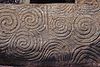
A long cold climatic spell prevailed until the end of the last glacial period about 9,000 years ago, and most of Ireland was covered with ice. Sea-levels were lower then, and Ireland, as with its neighbour Britain, rather than being islands, were part of a greater continental Europe. Mesolithic stone age inhabitants arrived some time after 8000 BC. Agriculture arrived with the Neolithic circa 4500 to 4000 BC, when sheep, goats, cattle and cereals were imported from southwest continental Europe. At the Céide Fields in County Mayo, an extensive Neolithic field system – arguably the oldest in the world[39] – has been preserved beneath a blanket of peat. Consisting of small fields separated from one another by dry-stone walls, the Céide Fields were farmed for several centuries between 3500 and 3000 BC. Wheat and barley were the principal crops.[40]

The Bronze Age, which began around 2500 BC, saw the production of elaborate gold as well as bronze ornaments, weapons and tools. The Iron Age in Ireland was supposedly associated with people known as Celts. They are traditionally thought to have colonised Ireland in a series of waves between the 8th and 1st centuries BC, with the Gaels, the last wave of Celts, conquering the island and dividing it into five or more kingdoms. Many scientists and academic scholars now favour a view that emphasises cultural diffusion from overseas over significant colonisation such as what Clonycavan Man was reported to be.[41][42]
The Romans referred to Ireland as Hibernia[43] and/or Scotia.[44] Ptolemy in AD 100 recorded Ireland's geography and tribes.[45] Native accounts are confined to Irish poetry, myth, and archaeology. The exact relationship between Rome and the tribes of Hibernia is unclear; the only references are a few Roman writings.
In early medieval times, a monarch (also known as the High King) presided over the (then five: the fifth being Meath) provinces of Ireland. These provinces too had their own kings, who were at least nominally subject to the monarch, who resided at Tara. The written judicial system was the Brehon Law, and it was administered by professional learned jurists who were known as the Brehons.
According to early medieval chronicles, in 431, Bishop Palladius arrived in Ireland on a mission from Pope Celestine I to minister to the Irish "already believing in Christ." The same chronicles record that Saint Patrick, Ireland's patron saint, arrived in 432. There is continued debate over the missions of Palladius and Patrick, but the general consensus is that they both existed.[46]
The druid tradition collapsed in the face of the spread of the new religion.[47] Irish Christian scholars excelled in the study of Latin and Greek learning and Christian theology in the monasteries that flourished, preserving Latin and Greek learning during the Early Middle Ages.[47][48] The arts of manuscript illumination, metalworking, and sculpture flourished and produced such treasures as the Book of Kells, ornate jewellery, and the many carved stone crosses that dot the island. From the 9th century, waves of Viking raiders plundered monasteries and towns, adding to a pattern of endemic raiding and warfare. Eventually Vikings settled in Ireland, and established many towns, including the modern day cities of Dublin, Cork, Limerick and Waterford.

From 1169, Ireland was entered by Cambro-Norman warlords, led by Richard de Clare, 2nd Earl of Pembroke (Strongbow),[49] on an invitation from the then King of Leinster. In 1171, King Henry II of England came to Ireland, using the 1155 Bull Laudabiliter issued to him by then Pope Adrian IV, to claim sovereignty over the island, and forced the Cambro-Norman warlords and some of the Gaelic Irish kings to accept him as their overlord. From the 13th century, English law began to be introduced. By the late 13th century the Norman-Irish had established the feudal system throughout most of lowland Ireland. Their settlement was characterised by the establishment of baronies, manors, towns and large land-owning monastic communities, and the county system. The towns of Dublin, Cork, Wexford, Waterford, Limerick, Galway, New Ross, Kilkenny, Carlingford, Drogheda, Sligo, Athenry, Arklow, Buttevant, Carlow, Carrick-on-Suir, Cashel, Clonmel, Dundalk, Enniscorthy, Kildare, Kinsale, Mullingar, Naas, Navan, Nenagh, Thurles, Wicklow, Trim and Youghal were all under Norman-Irish control.
In the 14th century the English settlement went into a period of decline and large areas, for example Sligo, were re-occupied by Gaelic septs. The medieval English presence in Ireland was deeply shaken by the Black Death, which arrived in Ireland in 1348.[50] From the late 15th century English rule was once again expanded, first through the efforts of the Earls of Kildare and Ormond then through the activities of the Tudor State under Henry VIII and Mary and Elizabeth. This resulted in the complete conquest of Ireland by 1603 and the final collapse of the Gaelic social and political superstructure at the end of the 17th century, as a result of English and Scottish Protestant colonisation in the Plantations of Ireland, and the Wars of the Three Kingdoms and the Williamite War in Ireland. Approximately 600,000 people, nearly half the Irish population, died during the Cromwellian conquest of Ireland.[51]

After the Irish Rebellion of 1641, Irish Catholics and nonconforming Protestants were barred from voting or attending the Irish Parliament. Under the penal laws (introduced from 1691) no Irish Catholic could sit in the Parliament of Ireland, even though some 90% of Ireland's population was native Irish Catholic. This ban was followed by others in 1703 and 1709 as part of a comprehensive system disadvantaging the Catholic community, and to a lesser extent, Protestant dissenters.[52] The new English Protestant ruling class was known as the Protestant Ascendancy. Towards the end of the 18th century the (entirely Protestant) Irish Parliament attained a greater degree of independence from the British Parliament than it had previously held.
In 1798, many members of the Protestant dissenter tradition made common cause with Catholics in a rebellion inspired and led by the Society of United Irishmen. It was staged with the aim of creating a fully independent Ireland as a state with a republican constitution. Despite assistance from France the Irish Rebellion of 1798 was put down by British forces.
In 1800, the British and subsequently the Irish Parliament passed the Act of Union which, in 1801, merged the Kingdom of Ireland and the Kingdom of Great Britain to create the United Kingdom of Great Britain and Ireland. The passage of the Act in the Irish Parliament was achieved with substantial majorities, in part (according to contemporary documents) through bribery, namely the awarding of peerages and honours to critics to get their votes.[53] Thus, Ireland became part of an extended United Kingdom, ruled directly by the UK Parliament in London.
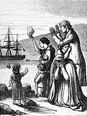
The Great Famine, which began in the 1840s, caused the deaths of one million Irish people, and caused over a million to emigrate.[54] By the late 1840s, as a result of the famine, half of all immigrants to the United States originated from Ireland. A total of 35 million Americans (12% of total population) reported Irish ancestry in the 2005 American Community Survey.[55] Mass emigration became entrenched as a result of the famine and the population continued to decline until late in the 20th century. The pre-famine peak was over 8 million recorded in the 1841 census. The population has never returned to this level.[56]
The 19th and early 20th century saw the rise of Irish nationalism among the Roman Catholic population. Daniel O'Connell led a successful campaign for Catholic Emancipation, which was passed by the United Kingdom parliament. A subsequent campaign for repeal of the Act of Union failed. Later in the century Charles Stewart Parnell and others campaigned for self-government within the Union or "Home Rule". Unionists, especially those located in the Northern part of the island, who considered themselves to be British as well as Irish, were strongly opposed to Home Rule, under which they felt they would be dominated by Catholic and Southern Irish interests.[57] To prevent Home Rule the Ulster Volunteers were formed in 1913 under the leadership of Lord Carson. This was followed by the Irish Volunteers, formed in 1914 to support the enactment of the Home Rule Act, which was suspended on the outbreak of World War I. Under John Redmond the National Volunteers broke away from the Irish Volunteers to serve with the Irish regiments of the New British Army.[58]
Armed rebellions, such as the Easter Rising of 1916 and the Irish War of Independence of 1919, occurred in this period. In 1921, a treaty was concluded between the British Government and the leaders of the Irish Republic. The Anglo-Irish Treaty recognised the two-state solution created in the Government of Ireland Act 1920. Northern Ireland was presumed to form a home rule state within the new Irish Free State unless it opted out. Northern Ireland had a majority Protestant population and opted out as expected, choosing to remain part of the United Kingdom, incorporating, however, within its border a significant Catholic and nationalist minority.[59] A Boundary Commission was set up to decide on the boundaries between the two Irish states, though it was subsequently abandoned after it recommended only minor adjustments to the border. Disagreements over some provisions of the treaty led to a split in the nationalist movement and subsequently to the Irish Civil War. The Civil War ended in 1923 with the defeat of the anti-treaty forces.
History since partition
Irish Independence: The Irish Free State, Éire, Ireland

The Anglo-Irish Treaty was ratified by the Dáil in January 1922 by a vote of 64 - 57. The minority refused to accept the result and this resulted in the Irish Civil War, which lasted until 1923. On 6 December 1922, in the middle of the Civil War, the Irish Free State came into being. During its early years the new state was governed by the victors of the Civil War. However, in the 1930s Fianna Fáil, the party of the opponents of the treaty, was elected into government. The party proposed, and the electorate accepted in a referendum in 1937, a new constitution which renamed the state "Éire or in the English language, Ireland" (article 4 of the Constitution).
The state was neutral during World War II, which was known internally as The Emergency. It offered some assistance to the Allies, especially in Northern Ireland. It is estimated[60] that around 50,000 volunteers from Éire/Ireland joined the British armed forces during the Second World War. In 1949, Ireland declared itself to be a republic.

Ireland experienced large-scale emigration in the 1950s and again in the 1980s. From 1987 the economy improved and the 1990s saw the beginning of unprecedented economic success, in a phenomenon known as the "Celtic Tiger".[61] By 2007 it had become the fifth richest country (in terms of GDP per capita) in the world, and the second richest in the European Union, moving from being a net recipient of the budget to becoming a net contributor during the next budget round (2007–13), and from a country of net emigration to one of net immigration. In October 2006, there were talks between Ireland and the U.S. to negotiate a new immigration policy between the two countries, in response to the growth of the Irish economy and desire of many U.S. citizens who sought to move to Ireland for work.[62]
Northern Ireland


Northern Ireland was created as an administrative division of the United Kingdom by the Government of Ireland Act 1920. From 1921 until 1972, Northern Ireland enjoyed limited self-government within the United Kingdom, with its own parliament and prime minister.
In the first half of the 20th century, Northern Ireland was largely spared the strife of the Civil War, but there were sporadic episodes of inter-communal violence between nationalists and unionists during the decades that followed partition. Although the Irish Free State was neutral during World War II, Northern Ireland as part of the United Kingdom was not, and became involved in the British war effort (albeit without military conscription as it was introduced in Great Britain). Belfast suffered a bombing raid from the German Luftwaffe in 1941.
In elections to the 1921–1972 regional government, the Protestant and Catholic communities in Northern Ireland each voted largely along sectarian lines, meaning that the Government of Northern Ireland (elected by "first past the post" from 1929) was controlled by the Ulster Unionist Party. Over time, the minority Catholic community felt increasingly alienated by the regional government, with further disaffection fuelled by practices such as gerrymandering of the local council in Derry, and alleged discrimination against Catholics in housing and employment[63] which was also alleged to have taken place against Protestants.[63][64][65]
In the late 1960s nationalist grievances were aired publicly in mass civil rights protests, which were often confronted by loyalist counter-protests.[66] The Government's reaction to confrontations was seen to be one-sided and heavy-handed, and law and order broke down as unrest and inter-communal violence increased.[67]
In August 1969, the regional government requested that the British Army be deployed to aid the police, who were exhausted after several nights of serious rioting. In 1970, the paramilitary Provisional IRA, which favoured the creation of a united Ireland, was formed and began a campaign against what it called the "British occupation of the six counties". Other groups, on both the unionist side and the nationalist side, participated in the violence and the period known as "The Troubles" began, resulting in over 3,600 deaths over the subsequent three decades.[68] Owing to the civil unrest during "The Troubles", the British government suspended home rule in 1972 and imposed "direct rule" from Westminster.
There were several (ultimately unsuccessful) political attempts to end "The Troubles", such as the Sunningdale Agreement of 1973 and the Anglo-Irish Agreement of 1985. In 1998, following a Provisional IRA ceasefire and multi-party talks, the Belfast Agreement was concluded and ratified by referendum. This agreement attempted to restore self-government to Northern Ireland on the basis of power-sharing between the two communities. Violence decreased greatly after the signing of the accord, and on 28 July 2005, the Provisional IRA announced the end of its armed campaign and international weapons inspectors supervised what they currently regard as the full decommissioning of the Provisional IRA's weapons.[69] The power-sharing assembly was suspended several times but restored from 8 May 2007.
From 2 August 2007, the government officially ended its military support of the police in Northern Ireland, and began withdrawing troops (in 1972, British troops numbered more than 25,000 in Northern Ireland; after the withdrawal, a garrison of approximately 1,500 remain on garrison duty).[70]
Culture
| Arts in Ireland |
|---|
 |
 |
Literature and the arts

For an island with a relatively small population, Ireland has made a large contribution to world literature in all its branches, mainly in English.[71] Poetry in Irish represents the oldest vernacular poetry in Europe with the earliest examples dating from the 6th century. Jonathan Swift, still often called the foremost satirist in the English language, was wildly popular in his day for works such as Gulliver's Travels and A Modest Proposal, and he remains so in modern times. More recently, Ireland has produced four winners of the Nobel Prize for Literature: George Bernard Shaw, William Butler Yeats, Samuel Beckett and Seamus Heaney. Although not a Nobel Prize winner, James Joyce is widely considered one of the most significant writers of the 20th century; Samuel Beckett himself refused to attend his own Nobel award ceremony, in protest of Joyce not having received the award. Joyce's 1922 novel Ulysses is considered one of the most important works of Modernist literature, and his life is celebrated annually on 16 June in Dublin as the Bloomsday celebrations.[72]
The story of art in Ireland begins with Stone Age carvings found at sites such as Newgrange.[73] It is traced through Bronze age artifacts, particularly ornamental gold objects, and the religious carvings and illuminated manuscripts of the mediæval period. During the course of the 19th and 20th centuries, a strong indigenous tradition of painting emerged, including such figures as John Butler Yeats, William Orpen, Jack Yeats and Louis le Brocquy.
Modern Irish literature is still often connected with its rural heritage, through writers like John McGahern and poets like Seamus Heaney.
In the performing arts, playwrights such as Seán O'Casey, Brian Friel, Sebastian Barry, Conor McPherson and Billy Roche have placed Ireland on the world stage.[74] There is a thriving performing arts culture all over the country, performing international as well as Irish plays. In addition, Galway has An Taibhdhearc, the Irish Language Theatre established in 1928.[75][76]
Music and dance
The Irish tradition of folk music and dance is known worldwide,[77] not least through the phenomenon of Riverdance.[78]
In the middle years of the 20th century, as Irish society was attempting to modernise, traditional music tended to fall out of favour, especially in urban areas.[79] During the 1960s, and inspired by the American folk music movement, there was a revival of interest in the Irish tradition. This revival was led by such groups as The Dubliners, The Chieftains, Emmet Spiceland, The Wolfe Tones, the Clancy Brothers, Sweeney's Men, and individuals like Seán Ó Riada and Christy Moore.[80]
Before too long, groups and musicians including Horslips, Van Morrison, and Thin Lizzy were incorporating elements of traditional music into a rock idiom to form a unique new sound. During the 1970s and 1980s, the distinction between traditional and rock musicians became blurred, with many individuals regularly crossing over between these styles of playing as a matter of course. This trend can be seen more recently in the work of artists like U2, Enya, Flogging Molly, Moya Brennan, The Saw Doctors, Bell X1, Damien Rice, The Corrs, Aslan, Sinéad O'Connor, Clannad, The Cranberries, Rory Gallagher, Westlife, B*witched, BoyZone, Gilbert O'Sullivan, Black 47, VNV Nation, Rob Smith, Ash, The Thrills, Stars of Heaven, Something Happens, A House, Sharon Shannon, Damien Dempsey, Declan O' Rourke, The Frames and The Pogues.
During the 1990s, a subgenre of folk metal emerged in Ireland that fused heavy metal music with Irish and Celtic music. The pioneers of this subgenre were Cruachan, Primordial and Waylander.
Irish music has shown an immense increase in popularity with many attempting to return to their roots. Some contemporary music groups stick closer to a "traditional" sound, including Altan, Téada, Danú, Dervish, Lúnasa, and Solas. Others incorporate multiple cultures in a fusion of styles, such as Afro Celt Sound System and Kíla.
The Republic of Ireland has done well in the Eurovision Song Contest, being the most successful country in the competition, with seven wins in 1970 with Dana, 1980 and 1987 with Johnny Logan, 1992 with Linda Martin, 1993 with Niamh Kavanagh, 1994 with Paul Harrington and Charlie McGettigan and in 1996 with Eimear Quinn.[81]
Science
Ireland has a rich history in science[82] and is known for its excellence in scientific research conducted at its many universities and institutions. Noted particularly is Ireland's contributions to fiber optics technology and related technologies.
The Irish philosopher and theologian Johannes Scotus Eriugena (c. 815–877) was considered one of the leading intellectuals of his era.

Robert Boyle (1627–1691) was an Irish natural philosopher, chemist, physicist, inventor and early gentleman scientist, largely regarded one of the founders of modern chemistry. He is best known for the formulation of Boyle's law, stating that the pressure and volume of an ideal gas are inversely proportional.[82]
Irish physicist John Tyndall (1820-1893) discovered the Tyndall effect, explaining why the sky is blue.
Other notable Irish physicists include Ernest Walton (winner of the 1951 Nobel Prize in Physics with Sir John Douglas Cockcroft for splitting the nucleus of the atom by artificial means and contributions in the development of a new theory of wave equation),[83] William Thomson, 1st Baron Kelvin (or Lord Kelvin) which the absolute temperature unit Kelvin is named after.[84] George Johnstone Stoney (who introduced the term electron in 1891), John Stewart Bell (the originator of Bell's Theorem and a paper concerning the discovery of the Bell-Jackiw-Adler anomaly), who was nominated for a Nobel prize, mathematical physicist George Francis FitzGerald, Sir George Gabriel Stokes and many others.[82]
Notable mathematicians include Sir William Rowan Hamilton (mathematician, physicist, astronomer and discoverer of quaternions), Francis Ysidro Edgeworth (influential in the development of neo-classical economics, including the Edgeworth box), John B. Cosgrave (specialist in number theory, former head of the mathematics department of St. Patrick's College and discoverer of a new 2000-digit prime number in 1999 and a record composite Fermat number in 2003) and John Lighton Synge (who made progress in different fields of science, including mechanics and geometrical methods in general relativity and who had mathematician John Nash as one of his students).
The Dublin Institute for Advanced Studies (DIAS) was established in 1940 by the Taoiseach Éamon de Valera.[85] In 1940, physicist Erwin Schrödinger received an invitation to help establish the Institute. He became the Director of the School for Theoretical Physics and remained there for 17 years, during which time he became a naturalized Irish citizen.[85]
Sport
- See also: List of Irish sports people
The most popular sports in Ireland are Gaelic Football and Association Football.[86] Together with Hurling and Rugby, they make up the four biggest team sports in Ireland. Gaelic Football is the most popular in terms of match attendance and community involvement,[87] and the All-Ireland Football Final is the biggest day in Ireland's sporting calendar. Association football, meanwhile, is the most commonly played team sport in Ireland and the most popular sport in which Ireland fields international teams.[88] Furthermore, there is significant Irish interest in the English and (to a lesser extent) Scottish soccer leagues. Many other sports are also played and followed, particularly golf and horse racing but also show jumping, greyhound racing, swimming, boxing, basketball, cricket, fishing, handball, motorsport, tennis and hockey.
Hurling and Gaelic football, along with camogie, ladies' Gaelic football, handball and rounders, make up the national sports of Ireland, collectively known as Gaelic games. All Gaelic games are governed by the Gaelic Athletic Association (GAA), with the exception of ladies' Gaelic football and camogie, which are governed by separate organisations. The GAA is organised on an all-Ireland basis with all 32 counties competing. The headquarters of the GAA (and the main stadium) is located at the 82,500[89] capacity Croke Park in north Dublin. Major GAA games are played there, including the semi-finals and finals of the All-Ireland Senior Football Championship and All-Ireland Senior Hurling Championship. During the redevelopment of the Lansdowne Road stadium, international rugby and soccer are played there.[90] All GAA players, even at the highest level, are amateurs, receiving no wages (although they are permitted to receive a certain amount of income from sources such as sponsorship, grants or scholarships).
The Irish Football Association (IFA) was originally the governing body for Association football throughout the island. The game has been played in Ireland since the 1860s (Cliftonville F.C. of Belfast being Ireland's oldest club) but remained a minority sport outside of Ulster until the 1880s. However, some clubs based outside Belfast felt that the IFA largely favoured Ulster-based, Protestant clubs in such matters as selection for the national team. Following an incident in which, despite an earlier promise, the IFA, for security reasons, moved an Irish Cup final replay from Dublin to Belfast,[91] the clubs based in what would soon become the Free State set up a new Football Association of the Irish Free State (FAIFS) - now known as the Football Association of Ireland (FAI) - in 1921. Despite being initially blacklisted by the Home Nations' associations, the FAI was recognised by FIFA in 1923 and organised its first international fixture in 1926 (against Italy). However, both the IFA and FAI continued to select their teams from the whole of Ireland, with some players earning international caps for matches with both teams. Both also referred to their respective teams as "Ireland". In 1950, FIFA directed the associations only to select players from within their respective territories, and in 1953 FIFA further clarified that the FAI's team was to be known only as "Republic of Ireland", and the IFA's team only as "Northern Ireland" (with certain exceptions). Northern Ireland qualified for the World Cup finals in 1958 (reaching the quarter-finals), 1982 and 1986. Team Republic qualified for the World Cup finals in 1990 (reaching the quarter-finals), 1994, 2002 and the European Championships in 1988.
The Irish rugby team includes players from north and south, and the Irish Rugby Football Union (IRFU) governs the sport on both sides of the border. Consequently in international rugby, the Ireland team represents the whole island. The Irish rugby team have played in every Rugby World Cup, making the quarter-finals at four of them. Ireland also hosted games during the 1991 and the 1999 Rugby World Cups (including a quarter-final). There are four professional provincial sides that contest the Magners League and Heineken Cup. Irish rugby has become increasingly competitive at both the international and provincial levels since the sport went professional in 1994. During that time, Ulster (1999[92]) and Munster (2006[93] and 2008)[94] have both won the Heineken Cup. The Ireland cricket team was among the associate nations which qualified for the 2007 Cricket World Cup, where it defeated Pakistan and finished second in its pool, earning a place in the Super 8 stage of the competition.
The Irish rugby league team is also organised on an all-Ireland basis. The team is made up predominantly of players based in England with Irish family connections, with others drawn from the local competition and Australia. Ireland reached the quarter-finals of the 2000 Rugby League World Cup.
As with rugby and Gaelic games, cricket, golf, tennis, rowing, hockey and most other sports are organised on an all-island basis. Greyhound racing and horse racing are both popular in Ireland: greyhound stadiums are well attended and there are frequent horse race meetings. The Republic is noted for the breeding and training of race horses and is also a large exporter of racing dogs. The horse racing sector is largely concentrated in the central east of the Republic. Boxing is also an all-island sport governed by the Irish Amateur Boxing Association. In 1992, Michael Carruth won a gold medal for boxing in the Barcelona Olympic Games. Irish athletics has seen some development in recent times, with Sonia O'Sullivan winning two notable medals at 5,000 metres; gold at the 1995 World Championships and silver at the 2000 Sydney Olympics. Gillian O'Sullivan won silver in the 20k walk at the 2003 World Championships, while sprint hurdler Derval O'Rourke won gold at the 2006 World Indoor Championship in Moscow.
Golf is a popular sport in Ireland and golf tourism is a major industry. The 2006 Ryder Cup was held at The K Club in County Kildare.[95] Pádraig Harrington became the first Irishman since Fred Daly in 1947 to win the British Open at Carnoustie in July 2007.[96] He successfully defended his title in July 2008 [97] before going on to win the PGA Championship in August.[98] Harrington became the first European to win the PGA Championship in 78 years (Tommy Armour in 1930), and was the first winner from Ireland.
The west coast of Ireland, Lahinch and Donegal Bay in particular, have popular surfing beaches; being fully exposed to the Atlantic Ocean. Donegal Bay is shaped like a funnel and catches West/South-West Atlantic winds, creating good surf - especially in winter. In recent years, Bundoran has hosted European championship surfing. The south-west of Ireland, such as the Dingle Peninsula and Lahinch, also has surf beaches. Scuba diving is increasingly popular in Ireland with clear waters and large populations of sea life, particularly along the western seaboard. There are also many shipwrecks along the coast of Ireland, with some of the best wreck dives being in Malin Head and off the County Cork coast. With thousands of lakes, over 14,000 kilometres (8,700 mi) of fish bearing rivers, and over 3,700 kilometres (2,300 mi) of coastline, Ireland is a popular angling destination. The temperate Irish climate is suited to sport angling. While salmon and trout fishing remain popular with anglers, salmon fishing in particular received a boost in 2006 with the closing of the salmon driftnet fishery. Coarse fishing continues to increase its profile. Sea angling is developed with many beaches mapped and signposted, and in recent times the range of sea angling species has increased.[99]
Places of interest
There are three World Heritage Sites on the island; these are the Bend of the Boyne, Skellig Michael and the Giant's Causeway.[100] [101] A number of other places are on the tentative list, for example the Burren and Mount Stewart.[102]
Some of the most visited sites in Ireland include Bunratty Castle, the Rock of Cashel, the Cliffs of Moher, Holy Cross Abbey and Blarney Castle.[103] Historically important monastic sites include Glendalough and Clonmacnoise, which are maintained as national monuments.[104]
Dublin is the most heavily touristed region,[103] and home to several top attractions such as the Guinness Storehouse and Book of Kells.[103] The west and south west (including the Killarney and Dingle regions in County Kerry, and Galway and the Aran Islands) are also popular tourist destinations.[103]
The stately homes, built during the 17th, 18th and 19th centuries in Palladian, Neoclassical and neo-Gothic styles, such as, Castle Ward, Castletown House, Bantry House, are of interest to tourists, and those converted into hotels, such as Ashford Castle, Castle Leslie and Dromoland Castle can be enjoyed as accommodation.[105]
 Blarney Castle. |  Giant's Causeway. | 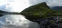 Killarney National Park. |
Demographics

Ireland has been inhabited for at least 9,000 years, although little is known about the paleolithic and neolithic inhabitants of the island (other than by inference from genetic research in 2004 that challenges the idea of migration from central Europe and proposes a flow along the Atlantic coast from Spain).[106][107] Early historical and genealogical records note the existence of dozens of different peoples that may or may not be "mythological" (Cruithne, Attacotti, Conmaicne, Eóganachta, Érainn, Soghain, to name but a few).

During the past 1,000 years or so, Vikings, Normans, Scots and English have all added to the indigenous gene pool.
Ireland's largest religious group is the Catholic Church (over 73% for the entire island, and about 86.8%[108] for the Republic), and most of the rest of the population adhere to one of the various Protestant denominations. The largest is the Anglican Church of Ireland. The Irish Muslim community is growing, mostly through increased immigration (see Islam in Ireland). The island also has a small Jewish community (see History of the Jews in Ireland). Over 4% of the Republic's population describe themselves as of no religion.[108]
Ireland has for centuries been a place of emigration, particularly to England, Scotland, the United States, Canada, and Australia, see Irish diaspora. With growing prosperity, Ireland has become a place of immigration instead. Since joining the EU in 2004, Polish people have been the largest source of immigrants (over 150,000)[109] from Central Europe, followed by other immigrants from Lithuania, the Czech Republic and Latvia.[110]
Ireland's high standard of living, high wage economy and EU membership attract many migrants from the newest of the European Union countries: Ireland has had a significant number of Romanian immigrants since the 1990s. In recent years, mainland Chinese have been migrating to Ireland in significant numbers (up to 100,000).[111] Nigerians, along with people from other African countries have accounted for a large proportion of the non-European Union migrants to Ireland.
Ireland is multilingual but predominantly English-speaking, with Irish, the first official language of the Republic, the second most commonly spoken language.[112] In the North, English is the de facto official language, but official recognition is afforded to both Irish and Ulster-Scots language. All three languages are spoken on both sides of the border. In recent decades, with the increase of immigration on an all-Ireland basis, many more languages have been introduced, particularly deriving from Asia and Eastern Europe, such as Chinese, Polish, Russian, Turkish and Latvian.
Cities
After Dublin (1.7m in Greater Dublin), Ireland's largest cities are Belfast (800,000 in Greater Belfast), Cork (380,000 in Greater Cork), Derry (94,329 in Derry Urban Area), Limerick (93,321 including suburbs), Galway (71,983), Lisburn (71,465), Waterford (49,240 including suburbs), Newry (27,433), Kilkenny (23,967 incl. suburbs) and Armagh (14,590).
Transport
Air

There are five main international airports in Ireland: Dublin Airport, Belfast International Airport (Aldergrove), Cork Airport, Shannon Airport and Ireland West Airport (Knock). Dublin Airport is the busiest airport in Ireland,[113] carrying over 22 million passengers per year;[114] a new terminal and runway is now under construction, costing over €2 billion.[115] All provide services to Great Britain and continental Europe, while Belfast International, Dublin, Shannon and Ireland West (Knock) also offer a range of transatlantic services. Shannon was once an important stopover on the trans-Atlantic route for refuelling operations[116] and, with Dublin, is still one of the Ireland's two designated transatlantic gateway airports.
There are several smaller regional airports: George Best Belfast City Airport, City of Derry Airport (Eglinton), Galway Airport, Kerry Airport (Farranfore), (Knock), Sligo Airport (Strandhill), Waterford Airport, and Donegal Airport (Carrickfinn). Scheduled services from these regional points are mostly limited to the rest of Ireland and Great Britain.
Airlines in Ireland include: Aer Lingus (the national airline of Ireland), Ryanair, Aer Arann and CityJet.
Rail

The rail network in Ireland was developed by various private companies, some of which received (British) Government funding in the late 19th century. The network reached its greatest extent by 1920. The broad gauge of 1,600 mm (5 ft 3 in)[117] was eventually settled upon throughout the island, although there were also hundreds of kilometres of 914 mm (3 ft) narrow gauge railways.[117]
Long distance passenger trains in the Republic are managed by Iarnród Éireann (Irish Rail) and connect most major towns and cities across the country.
In Dublin, two local rail networks provide transportation in the city and its immediate vicinity. The Dublin Area Rapid Transit (DART) links the city centre with coastal suburbs, while a new light rail system named Luas, opened in 2004, transports passengers to the central and western suburbs. Several more Luas lines are planned as well as an eventual upgrade to metro. The DART is run by Iarnród Éireann while the Luas is being run by Veolia under franchise from the Railway Procurement Agency (R.P.A.).
Under the Irish government's Transport 21 plan, reopening the Navan-Clonsilla rail link, the Cork-Midleton rail link and the Western Rail Corridor are amongst plans for Ireland's railways.[118]
In Northern Ireland, all rail services are provided by Northern Ireland Railways (N.I.R.), part of Translink. Services in Northern Ireland are sparse in comparison to the rest of Ireland or Britain. A large railway network was severely curtailed in the 1950s and 1960s (in particular by the Ulster Transport Authority). The current situation includes suburban services to Larne, Newry and Bangor, as well as services to Derry. There is also a branch from Coleraine to Portrush. Waterside Station in Derry is the main railway station for Derry as well as County Donegal in Ireland, which no longer has a rail network.
Ireland also has one of the largest dedicated freight railways in Europe, operated by Bord na Móna. This company has narrow gauge railways[117] totalling nearly 1,400 kilometres (870 miles).[119]
Roads

Motorists must drive on the left in Ireland, as in Great Britain, Australia, New Zealand, India, Hong Kong, Japan, and a number of other countries. Tourists driving on the wrong side of the road cause serious accidents every year.[120] The island of Ireland has an extensive road network, with a (developing) motorway network fanning out from Belfast, Cork and Dublin. Historically, land owners developed most roads and later Turnpike Trusts collected tolls so that as early as 1800 Ireland had a 16,100 km (10,000 mi) road network.[121]
In recent years the Irish Government launched Transport 21 which is the largest investment project ever in Ireland's transport system - with €34 billion being invested from 2006 until 2015. Work on a number of road projects has already commenced while a number of objectives have already been completed.[122] The Transport 21 plan can largely be divided into five categories, Metro / Luas, Heavy rail, roads, buses and airports. The plan for Transport 21 was announced on 1 November 2005 by the then Minister for Transport, Martin Cullen.[123]
The year 1815 marked the inauguration of the first horsecar service from Clonmel to Thurles and Limerick run by Charles Bianconi.[124] Now, the main bus companies are Bus Éireann in the Republic and Ulsterbus, a division of Translink, in Northern Ireland, both of which offer extensive passenger service in all parts of the island. Dublin Bus specifically serves the greater Dublin area, and a further division of Translink called Metro, operates services within the greater Belfast area. Translink also operate Ulsterbus Foyle in the Derry Urban Area.
All speed limit signs in the Republic changed to the metric system in 2005. Some direction signs still show distance in miles.[125] Use of imperial measurements are usually limited to pints of beer in pubs, and informal measurement of human height (feet and inches) and weight (usually stones, but pounds and ounces for infants).
Energy network
For much of their existence electricity networks in the Republic of Ireland and Northern Ireland were entirely separate. Both networks were designed and constructed independently, but are now connected with three interlinks and also connected through Britain to mainland Europe. The Electricity Supply Board (ESB) in the Republic drove a rural electrification programme in the 1940s until the 1970s.

Ireland, north and south has faced difficulties in providing continuous power at peak load.[citation needed] The situation in the North is complicated by the issue of private companies not supplying NIE with enough power, while in the South, the ESB has failed to modernise its power stations. In the latter case, availability of power plants has averaged 66% recently, one of the worst such figures in Western Europe.
The natural gas network is also now all-Ireland, with an interconnector from Antrim to Scotland, and a further two interconnectors from Dublin to Britain. Most of Ireland's gas now comes through the interconnectors with a decreasing supply from the Kinsale field. The Corrib Gas Field off the coast of County Mayo has yet to come online, and is facing some localised opposition over the controversial decision to refine the gas onshore.
There have been recent efforts in Ireland to use renewable energy such as wind energy with large wind farms being constructed in coastal counties such as Donegal, Mayo and Antrim. What will be the world's largest offshore wind farm is currently being developed at Arklow Bank off the coast of Wicklow. It is predicted to generate 10% of Ireland's energy needs when it is complete. These constructions have in some cases been delayed by opposition from locals, most recently on Achill Island, some of whom consider the wind turbines to be unsightly. Another issue in the Republic of Ireland is the failure of the aging network to cope with the varying availability of power from such installations. The ESB's Turlough Hill is the only energy storage mechanism in Ireland.[126]
No comments:
Post a Comment