Guatemala
| Republic of Guatemala República de Guatemala | ||||||
|---|---|---|---|---|---|---|
| ||||||
| Motto: "Libre Crezca Fecundo" "Grow Free and Fertile" | ||||||
| Anthem: Himno Nacional de Guatemala | ||||||
 | ||||||
| Capital (and largest city) | Guatemala City 14°38′N 90°30′W / 14.633, -90.5 | |||||
| Official languages | Spanish (de facto) | |||||
| Demonym | Guatemalan | |||||
| Government | Presidential republic | |||||
| - | President | Álvaro Colom Caballeros | ||||
| - | Vice President | Rafael Espada | ||||
| Independence | from Spain | |||||
| - | Date | 15 September 1821 | ||||
| Area | ||||||
| - | Total | 108,890 km2 (106th) 42,042 sq mi | ||||
| - | Water (%) | 0.4 | ||||
| Population | ||||||
| - | July 2008 estimate | 13,000,001 (70th) | ||||
| - | July 2007 census | 12,728,111 | ||||
| - | Density | 134.6/km2 (85th) 348.6/sq mi | ||||
| GDP (PPP) | 2007 estimate | |||||
| - | Total | $62.580 billion[1] | ||||
| - | Per capita | $4,702[1] | ||||
| GDP (nominal) | 2007 estimate | |||||
| - | Total | $33.694 billion[1] | ||||
| - | Per capita | $2,531[1] | ||||
| Gini (2002) | 55.1 (high) | |||||
| HDI (2007) | ▲ 0.689 (medium) (118th) | |||||
| Currency | Quetzal (GTQ) | |||||
| Time zone | (UTC-6) | |||||
| Drives on the | right | |||||
| Internet TLD | .gt | |||||
| Calling code | 502 | |||||


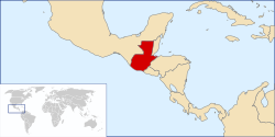
Guatemala (Spanish: República de Guatemala, Spanish pronunciation: [re̞ˈpuβ̞lika ð̞e̞ ɣ̞wate̞ˈmala]) is a country in Central America bordered by Mexico to the north and west, the Pacific Ocean to the southwest, Belize and the Caribbean to the northeast, and Honduras and El Salvador to the southeast.
A representative democracy, its capital is Guatemala City. The nation has been stable since 1996 and has been in a state of continuous development and economic growth. Guatemala's abundance of biologically significant and unique ecosystems contribute to Mesoamerica's designation as a biodiversity hotspot.[2]
Contents1 History
|
History

Pre-Columbian
The first evidence of human settlers in Guatemala goes back to at least 12,000 BC. There is some evidence that may put this date as early as 18,000 BC, such as obsidian arrow heads found in various parts of the country.[3] There is archaeological proof that early Guatemalan settlers were hunters and gatherers, but pollen samples from Petén and the Pacific coast indicate that maize cultivation was developed by 3500 BC.[4] Archaic sites have been documented in Quiché in the Highlands and Sipacate, Escuintla on the central Pacific coast (6500 BC).
Archaeologists divide the pre-Columbian history of Mesoamerica into 3 periods: the Pre-Classic from 2000 BC to 250 AD, the Classic from 250 to 900 AD, and the Calistic from 900 to 1500 AD.[5] Until recently, the Pre-Classic was regarded as a formative period, with small villages of farmers who lived in huts, and few permanent buildings, but this notion has been challenged by recent discoveries of monumental architecture from that period, such as an altar in La Blanca, San Marcos, from 1000 BC; ceremonial sites at Miraflores and El Naranjo from 801 BC; the earliest monumental masks; and the Mirador Basin cities of Nakbé, Xulnal, El Tintal, Wakná and El Mirador.
El Mirador was by far the most populated city in pre-Columbian America. Both the El Tigre and Monos pyramids encompass a volume greater than 250,000 cubic meters.[6] Mirador was the first politically organized state in America, named the Kan Kingdom in ancient texts. There were 26 cities, all connected by Sacbeob (highways), which were several kilometers long, up to 40 meters wide, and two to four meters above the ground, paved with stucco, that are clearly distinguishable from the air in the most extensive virgin tropical rain forest in Mesoamerica.
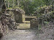
The Classic period of Mesoamerican civilization corresponds to the height of the Maya civilization, and is represented by countless sites throughout Guatemala, although the largest concentration is in Petén. This period is characterized by heavy city-building, the development of independent city-states, and contact with other Mesoamerican cultures.
This lasted until around 900 AD, when the Classic Maya civilization collapsed. The Maya abandoned many of the cities of the central lowlands or were killed off by a drought-induced famine.[7] Scientists debate the cause of the Classic Maya Collapse, but gaining currency is the Drought Theory discovered by physical scientists studying lakebeds, ancient pollen, and other tangible evidence.[8] A series of prolonged droughts in what is otherwise a seasonal desert is thought to have decimated the Maya, who were primarily reliant upon regular rainfall.[citation needed] The Post-Classic period is represented by regional kingdoms such as the Itzá and Ko'woj in the lakes area in Petén, and the Mam, Ki'ch'es, Kack'chiquel, Tz'utuh'il, Pokom'chí, Kek'chi and Chortí in the Highlands. These cities preserved many aspects of Mayan culture, but would never equal the size or power of the Classic cities.
Colonial

After arriving in what was named the New World, the Spanish mounted several expeditions to Guatemala, beginning in 1518. Before long, Spanish contact resulted in an epidemic that devastated native populations. Hernán Cortés, who had led the Spanish conquest of Mexico, granted a permit to Captains Gonzalo de Alvarado and his brother, Pedro de Alvarado, to conquer this land. Alvarado at first allied himself with the Cakchiquel nation to fight against their traditional rivals the Quiché nation. Alvarado later turned against the Cakchiquels, and eventually held the entire region under Spanish domination.
During the colonial period, Guatemala was an Audiencia and a Captaincy General (Capitanía General de Guatemala) of Spain, and a part of New Spain (Mexico).[citation needed] It extended from the modern Mexican states of Tabasco and Chiapas (including the then separate administration of Soconusco) to Costa Rica. This region was not as rich in minerals (gold and silver) as Mexico and Peru, and was therefore not considered to be as important. Its main products were sugarcane, cocoa, blue añil dye, red dye from cochineal insects, and precious woods used in artwork for churches and palaces in Spain.
The first capital was named Tecpan Guatemala, founded in July 25, 1524 with the name of Villa de Santiago de Guatemala and was located near Iximché, the Cakchiquel's capital city, It was moved to Ciudad Vieja on November 22, 1527, when the Cakchiquel attacked the city. On September 11, 1541 the city was flooded when the lagoon in the crater of the Agua Volcano collapsed due to heavy rains and earthquakes, and was moved 4 miles (6 km) to Antigua Guatemala, on the Panchoy Valley, now a UNESCO World Heritage Site. This city was destroyed by several earthquakes in 1773-1774, and the King of Spain, granted the authorization to move the capital to the Ermita Valley, named after a Catholic church to the Virgen de El Carmen, in its current location, founded in January 2, 1776.
Independence and 19th century

On September 15, 1821, the Captaincy-general of Guatemala (formed by Chiapas, Guatemala, El Salvador, Nicaragua, Costa Rica, and Honduras) officially proclaimed its independence from Spain and its incorporation into the Mexican Empire, which was dissolved two years later. This region had been formally subject to New Spain throughout the colonial period, but as a practical matter was administered separately. All but Chiapas soon separated from Mexico after Agustín I from Mexico was forced to abdicate.
The Guatemalan provinces formed the United Provinces of Central America, also called the Central American Federation (Federacion de Estados Centroamericanos). That federation dissolved in civil war from 1838 to 1840 (See: History of Central America). Guatemala's Rafael Carrera was instrumental in leading the revolt against the federal government and breaking apart the Union. During this period a region of the Highlands, Los Altos, declared independence from Guatemala, but was annexed by Carrera, who dominated Guatemalan politics until 1865, backed by conservatives, large land owners and the church.
Guatemala's "Liberal Revolution" came in 1871 under the leadership of Justo Rufino Barrios, who worked to modernize the country, improve trade, and introduce new crops and manufacturing. During this era coffee became an important crop for Guatemala. Barrios had ambitions of reuniting Central America and took the country to war in an unsuccessful attempt to attain this, losing his life on the battlefield in 1885 against forces in El Salvador.
1944 to present
On July 4, 1944, Dictator Jorge Ubico Castañeda was forced to resign his office in response to a wave of protests and a general strike. His replacement, General Juan Federico Ponce Vaides, was later also forced out of office on October 20, 1944 by a coup d'état led by Major Francisco Javier Arana and Captain Jacobo Arbenz Guzmán. About 100 people were killed in the coup. The country was led by a military junta made up of Arana, Arbenz, and Jorge Toriello Garrido. The Junta called Guatemala's first free election, which was won with a majority of 85 percent by the prominent writer and teacher Juan José Arévalo Bermejo, who had lived in exile in Argentina for 14 years. Arévalo was the first democratically elected president of Guatemala to fully complete the term for which he was elected. His "Christian Socialist" policies, inspired by the U.S. New Deal, were criticized by landowners and the upper class as "communist."
This period was also the beginning of the Cold War between the U.S. and the USSR, which was to have a considerable influence on Guatemalan history. From the 1950s through the 1990s, the U.S. government directly supported Guatemala's army with training, weapons, and money.
In 1954, Arévalo's freely elected Guatemalan successor, Jacobo Arbenz, was overthrown in a coup orchestrated by the U.S. Central Intelligence Agency (CIA) in the 1954 Guatemalan coup d'état. Colonel Carlos Castillo Armas was installed as president in 1954 and ruled until he was assassinated by a member of his personal guard in 1957.
In the election that followed, General Miguel Ydígoras Fuentes assumed power. He is most celebrated for challenging the Mexican president to a gentleman's duel on the bridge on the south border to end a feud on the subject of illegal fishing by Mexican boats on Guatemala's Pacific coast, two of which were sunk by the Guatemalan Air Force. Ydigoras authorized the training of 5,000 anti-Castro Cubans in Guatemala. He also provided airstrips in the region of Petén for what later became the failed Bay of Pigs Invasion in 1961. Ydigoras' government was ousted in 1963 when the Air Force attacked several military bases. The coup was led by his Defense Minister, Colonel Enrique Peralta Azurdia.
In 1966, Julio César Méndez Montenegro was elected president of Guatemala under the banner "Democratic Opening." Mendez Montenegro was the candidate of the Revolutionary Party, a center-left party which had its origins in the post-Ubico era. It was during this time that rightist paramilitary organizations, such as the "White Hand" (Mano Blanca), and the Anticommunist Secret Army, (Ejército Secreto Anticomunista), were formed. Those organizations were the forerunners of the infamous "Death Squads." Military advisers of The United States Army Special Forces (Green Berets) were sent to Guatemala to train troops and help transform its army into a modern counter-insurgency force, which eventually made it the most sophisticated in Central America.
In 1970, Colonel Carlos Manuel Arana Osorio was elected president. A new guerrilla movement entered the country from Mexico, into the Western Highlands in 1972. In the disputed election of 1974, General Kjell Lauguerud García defeated General Efraín Ríos Montt, a candidate of the Christian Democratic Party, who claimed that he had been cheated out of a victory through fraud. On February 4, 1976, a major earthquake destroyed several cities and caused more than 25,000 deaths. In 1978, in a fraudulent election, General Romeo Lucas García assumed power. The 1970s saw the birth of two new guerrilla organizations, The Guerrilla Army of the Poor (EGP) and the Organization of the People in Arms (ORPA), who began and intensified by the end of the seventies, guerrilla attacks that included urban and rural guerrilla warfare, mainly against the military and some of the civilian supporters of the army. In 1979, the U.S. president, Jimmy Carter, ordered a ban on all military aid to the Guatemalan Army because of the widespread and systematic abuse of human rights.
In 1980, a group of Quiché Indigenous Peoples took over the Spanish Embassy to protest army massacres in the countryside. The Guatemalan government launched an assault that killed almost everyone inside as a result of a fire that consumed the building. The Guatemalan government claimed that the activists set the fire and immolated themselves.[9] However, the Spanish ambassador, who survived the fire, disputed this claim, claiming that the Guatemalan police intentionally killed almost everyone inside and set the fire to erase traces of their acts. As a result of this incident, the government of Spain broke diplomatic relations with Guatemala. This government was overthrown in 1982. General Efraín Ríos Montt was named President of the military junta, continuing the bloody campaign of torture, disappearances, and "scorched earth" warfare. The country became a pariah state internationally. Ríos Montt was overthrown by General Óscar Humberto Mejía Victores, who called for an election of a national constitutional assembly to write a new constitution, leading to a free election in 1986, which was won by Vinicio Cerezo Arévalo, the candidate of the Christian Democracy Party.
In 1982, the four Guerrilla groups, EGP, ORPA, FAR and PGT, merged and formed the URNG, influenced by the Salvadoran guerrilla FMLN, the Nicaraguan FSLN and Cuba's Government, in order to become stronger. As a result of the Army's "scorched earth" tactics in the countryside, more than 45,000 Guatemalans fled across the border to Mexico. The Mexican government placed the refugees in camps in Chiapas and Tabasco.
In 1992, the Nobel Peace Prize was awarded to Rigoberta Menchú for her efforts to bring international attention to the government-sponsored genocide against the indigenous population.
The Guatemalan Civil War ended in 1996 with a peace accord between the guerrillas and the government, negotiated by the United Nations through intense brokerage by nations such as Norway and Spain. Both sides made major concessions. The guerrilla fighters disarmed and received land to work. According to the U.N.-sponsored truth commission the ("Commission for Historical Clarification"), government forces and state-sponsored paramilitaries were responsible for over 93% of the human rights violations during the war.[10] During the first 10 years, the victims of the state-sponsored terror were primarily students, workers, professionals, and opposition figures, but in the last years they were thousands of mostly rural Mayan farmers and non-combatants. More than 450 Mayan villages were destroyed and over 1 million people became internal and external refugees. In certain areas, such as Baja Verapaz, the Truth Commission considered that the Guatemalan state engaged in an intentional policy of genocide against particular ethnic groups in the Civil War.[10] In 1999, U.S. president Bill Clinton stated that the United States was wrong to have provided support to Guatemalan military forces that took part in the brutal civilian killings.[11]
Since the peace accords, Guatemala has witnessed successive democratic elections, most recently in 2007. The past government has signed free trade agreements with the United States and the rest of Central America through CAFTA, and other agreements with Mexico. In 2007 elections were held in Guatemala. El Partido Nacional de la Esperanza and its president candidate Álvaro Colom won the presidency as well as the majority of the seats in congress.
Politics
Guatemala is a presidential representative democratic republic, whereby the President of Guatemala is both head of state and head of government, and of a multi-party system. Executive power is exercised by the government. Legislative power is vested in both the government and the Congress of the Republic. The Judiciary is independent of the executive and the legislature. Álvaro Colom is the President of Guatemala as of 14 January 2008
Foreign Relations
The Chair of the Latin America and the Caribbean group is the Permanent Mission of Guatemala to the United Nations.[12][13]
Departments and municipalities

Guatemala is divided into 22 departments (departamentos) and sub-divided into about 332 municipalities (municipios).
The departments include:
|
|
Guatemala is heavily centralized. Transportation, communications, business, politics, and the most relevant urban activity take place in Guatemala City. There is only one highway that traverses the greater communities of the country. Some coastal towns are accessible only through the coast by boats.
Guatemala City has about 2 million inhabitants within the city limits and more than 5 million within in the urban area. This is a significant percentage of the population (12 million).[verification needed]
Geography


Guatemala is mountainous, except for the south coastal area and the vast northern lowlands of Petén department. Two mountain chains enter Guatemala from west to east, dividing the country into three major regions: the highlands, where the mountains are located; the Pacific coast, south of the mountains; and the Petén region, north of the mountains. All major cities are located in the highlands and Pacific coast regions; by comparison, Petén is sparsely populated. These three regions vary in climate, elevation, and landscape, providing dramatic contrasts between hot and humid tropical lowlands and colder and drier highland peaks. Volcán Tajumulco, at 4,220 meters, is the highest point in the Central American states.
The rivers are short and shallow in the Pacific drainage basin, larger and deeper in the Caribbean and the Gulf of Mexico drainage basins, which include the Polochic and Dulce Rivers, which drain into Lake Izabal, the Motagua River, the Sarstún that forms the boundary with Belize, and the Usumacinta River, which forms the boundary between Petén and Chiapas, Mexico.
Guatemala has long claimed all or part of the territory of neighbouring Belize, formerly part of the Spanish colony, and currently an independent Commonwealth Realm which recognises Queen Elizabeth II as its Head of State. Guatemala recognized Belize's independence in 1990, but their territorial dispute is not resolved. Negotiations are currently underway under the auspices of the Organization of American States and the Commonwealth of Nations to conclude it.[14][15]
Natural disasters
Guatemala's location between the Caribbean Sea and Pacific Ocean makes it a target for hurricanes, such as Hurricane Mitch in 1998 and Hurricane Stan in October 2005, which killed more than 1,500 people. The damage was not wind related, but rather due to significant flooding and resulting mudslides.
Guatemala's highlands lie along the Motagua Fault, part of the boundary between the Caribbean and North American tectonic plates. This fault has been responsible for several major earthquakes in historic times, including a 7.5 magnitude tremor on February 4, 1976 which killed more than 25,000 people. In addition, the Middle America Trench, a major subduction zone lies off the Pacific coast. Here, the Cocos Plate is sinking beneath the Caribbean Plate, producing volcanic activity inland of the coast. Guatemala has 37 volcanoes, four of them active: Pacaya, Santiaguito, Fuego and Tacaná.
Biodiversity
The country has 14 ecoregions ranging from Mangrove forests, to both ocean littorals with 5 different ecosystems. Guatemala has 252 listed wetlands, including 5 lakes, 61 lagoons, 100 rivers, and 3 swamps.[2]PDF (63.1 KiB) Tikal National Park, was the first mixed UNESCO World Heritage Site. Guatemala is a country of distinct fauna. It has some 1246 known species. Of these, 6.7% are endemic and 8.1% are threatened.[citation needed] Guatemala is home to at least 8681 species of vascular plants, of which 13.5% are endemic. 5.4% of Guatemala is protected under IUCN categories I-V.
Demographics

According to the CIA World Fact Book, Guatemala has a population of 12,728,111 (2007 est). The majority of the population is Ladino, also called Mestizo (mixed Amerindian and Spanish), and Whites (primarily of Spanish, but also those of German, English, Italian, and Scandinavian descent), they make up a combined total of 59.4%. Amerindians populations include the K'iche 9.1%, Kaqchikel 8.4%, Mam 7.9% and Q'eqchi 6.3%. 8.6% of the population is "other Mayan", 0.2% is indigenous non-Mayan, and 0.1% is "other".[16] There are smaller communities present. The Garífuna, who are descended from African slaves, live mainly in Livingston and Puerto Barrios, and other blacks and mulattos. There are also Arabs of Lebanese and Syrian descent, and Asians, mostly of Chinese descent. There is also a growing Korean community in Guatemala City and in nearby Mixco, currently numbering about 50,000.[3] Guatemala's German population is credited with bringing the tradition of a Christmas tree to the country.[17]
In 1900, Guatemala had a population of 885,000.[18] Over the course of the twentieth century the population of the country grew, the fastest growth in the Western Hemisphere. The ever-increasing pattern of emigration to the U.S. has led to the growth of Guatemalan communities in California, Florida, Illinois, New York, Texas, Rhode Island and elsewhere since the 1970s.[19]
Diaspora
The Civil War forced many Guatemalans to start lives outside of their country. The majority of the Guatemalan diaspora is located in the United States with estimates ranging from 480,000[20] to 1 million.[21] The difficulty in getting accurate counts for Guatemalans abroad is because many of them are refugee claimants awaiting determination of their status.[22] Below are current statistics for certain countries:
Country  | Count |
|---|---|
| 489,426 – 1,102,090 | |
| 23,529 – 190,000 | |
| 14,693[citation needed] | |
| 34,665[4] | |
| 5,989[citation needed] | |
| 5,172[citation needed] | |
| 4,209[citation needed] | |
| 5,000[5] |
Economy

According to the CIA World Factbook, Guatemala's GDP per capita is US$5,000; however, this developing country still faces many social problems and is among the 10 poorest countries in Latin America.[23] The distribution of income remains highly unequal with approximately 29%[24] of the population living below the poverty line and just over 400,000 (3.2%) unemployed.
Remittances from Guatemalans who fled to the United States during the civil war now constitute the largest single source of foreign income (more than the combined value of exports and tourism).[25]
In last years the exporter sector of nontraditional products has grown dynamically representing more than 53 percent of global exports. Some of the main products for export are fruits, vegetables, flowers, handicrafts, cloths and others.
Gross Domestic Product (GDP) in purchasing power parity (PPP) in 2006 was estimated at $61.38 billion USD. The service sector is the largest component of GDP at 58.7%, followed by the agriculture sector at 22.1% (2006 est.). The industrial sector represents only 19.1% of GDP (2006 est.). The agricultural sector accounts for about one-fourth of GDP, two-fifths of exports, and half of the labor force. Organic coffee, sugar, textiles, fresh vegetables, and bananas are the country's main exports. Inflation was 5.7% in 2006.
The 1996 peace accords that ended the decades-long Civil War removed a major obstacle to foreign investment. Tourism has become an increasing source of revenue for Guatemala.
In March 2005 Guatemala's congress ratified the Dominican Republic - Central American Free Trade Agreement (DR-CAFTA) between several Central American nations and the United States.[26] Guatemala also has free trade agreements with Taiwan and Colombia.
Culture
Guatemala City is home to many of the nation's libraries and museums, including the National Archives, the National Library, and the Museum of Archeology and Ethnology, which has an extensive collection of Maya artifacts. There are private museums, such as the Ixchel, which focuses on textiles, and the Popol Vuh, which focuses on Maya archaeology. Both museums are housed inside the Universidad Francisco Marroquín campus. Almost each of the 329 municipalities in the country has a small museum.

- Literature
The Guatemala National Prize in Literature is a one-time only award that recognizes an individual writer's body of work. It has been given annually since 1988 by the Ministry of Culture and Sports.
Miguel Ángel Asturias, won the literature Nobel Prize in 1967. Among his famous books is "El Señor Presidente", a novel based on the government of Manuel Estrada Cabrera.
- Music
The Music of Guatemala comprises a number of styles and expressions. The Maya had an intense musical practice, as is documented by iconography. Guatemala was also one of the first regions in the New World to be introduced to European music, from 1524 on. Many composers from the Renaissance, baroque, classical, romantic, and contemporary music styles have contributed works of all genres. The marimba is the national instrument that has developed a large repertoire of very attractive pieces that have been popular for more than a century. The Historia General de Guatemala has published a series of CDs of historical Music of Guatemala, in which every style is present, from the Maya, colonial period, independent and republican eras to current times. There are many contemporary music groups in Guatemala from Caribbean music, salsa, punta (Garifuna influenced), Latin pop, Mexican regional, and mariachi. There is also a vibrant scene for what is known in the Hispanic world as rock en Español (Spanish rock).
Language
- See also: Central American Spanish

Although Spanish is the official language, it is not universally spoken among the indigenous population, nor is it often spoken as a second language. Twenty-one distinct Mayan languages are spoken, especially in rural areas, as well as several non-Mayan Amerindian languages, such as the indigenous Xinca, and Garifuna, an Arawakan language spoken on the Caribbean coast. According to Decreto Número 19-2003, twenty-three languages are recognized as National Languages.[27]
The Peace Accords signed in December 1996 provide for the translation of some official documents and voting materials into several indigenous languages (see summary of main substantive accords) and mandate the provision of interpreters in legal cases for non-Spanish speakers. The accord also sanctioned bilingual education in Spanish and indigenous languages. It is common for indigenous Guatemalans to learn or speak between two to five of the nation's other languages, including Spanish.[citation needed]
Religion

50-60% of the population is Catholic, 40% Protestant, and 1% follow the indigenous Mayan faith. Catholicism was the only official religion during the colonial era.[citation needed] However, Protestantism has increased markedly in recent decades. More than one third of Guatemalans are Protestant, chiefly Evangelicals and Pentecostals. Protestantism and traditional Mayan religions are practiced by an estimated 40% and 1% of the population, respectively.[6] It is common for traditional Mayan practices to be incorporated into Catholic ceremonies and worship, a phenomenon known as syncretism. The practice of traditional Mayan religion is increasing as a result of the cultural protections established under the peace accords. The government has instituted a policy of providing altars at every Mayan ruin found in the country so that traditional ceremonies may be performed there.
There are also small communities of Jews estimated between 1200 and 2000[7], Muslims (1200), Buddhists at around 9000 to 12000[8], and members of other faiths and those who do not profess any faith.
The Church of Jesus Christ of Latter-Day Saints has over 210,000 members in Guatemala.[9]
Education
The government runs a number of public elementary and secondary-level schools. These schools are free, though the cost of uniforms, books, supplies, and transportation makes them less accessible to the poorer segments of society. Many middle and upper-class children go to private schools. The country also has one public university (USAC or Universidad de San Carlos de Guatemala), and 9 private ones (see List of universities in Guatemala). USAC was one of the first universities in America. It was officially declared a university on January 31, 1676 by royal command of King Charles II of Spain. Only 69.1% of the population aged 15 and over are literate, the lowest literacy rate in Central America. Although it has the lowest literacy rate, Guatemala is expected to change this within the next 10 years.[28]
No comments:
Post a Comment