Zambia
| Republic of Zambia | ||||||
|---|---|---|---|---|---|---|
| ||||||
| Motto: "One Zambia, One Nation" | ||||||
| Anthem: Stand and Sing of Zambia, Proud and Free | ||||||
 | ||||||
| Capital (and largest city) | Lusaka 15°25′S 28°17′E / -15.417, 28.283 | |||||
| Official languages | English | |||||
| Recognised regional languages | Nyanja, Bemba, Lunda, Tonga, Lozi, Luvale, Kaonde, and about 65 other indigenous languages. | |||||
| Demonym | Zambian | |||||
| Government | Republic | |||||
| - | President | Rupiah Banda | ||||
| - | Vice President | George Kunda | ||||
| Independence | from the United Kingdom | |||||
| - | Date | 24 October 1964 | ||||
| Area | ||||||
| - | Total | 752,618 km2 [1](39th) 290,587 sq mi | ||||
| - | Water (%) | 1 | ||||
| Population | ||||||
| - | July 2005 estimate | 11,668,000[2] (seventy first) | ||||
| - | 2000 census | 9,885,591[3] | ||||
| - | Density | 16/km2 (191st) 40/sq mi | ||||
| GDP (PPP) | 2007 estimate | |||||
| - | Total | $16.086 billion[4] | ||||
| - | Per capita | $1,323[4] | ||||
| GDP (nominal) | 2007 estimate | |||||
| - | Total | $11.411 billion[4] | ||||
| - | Per capita | $938[4] | ||||
| Gini (2002–03) | 42.1 (medium) | |||||
| HDI (2007) | ▲ 0.434 (low) (165th) | |||||
| Currency | Zambian kwacha (ZMK) | |||||
| Time zone | CAT (UTC+2) | |||||
| - | Summer (DST) | not observed (UTC+2) | ||||
| Drives on the | left | |||||
| Internet TLD | .zm | |||||
| Calling code | 260 | |||||


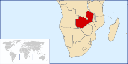
The Republic of Zambia (pronounced /ˈzæmbiə/) is a landlocked country in Southern Africa. The neighbouring countries are the Democratic Republic of the Congo to the north, Tanzania to the north-east, Malawi to the east, Mozambique, Zimbabwe, Botswana, and Namibia to the south, and Angola to the west. The capital city is Lusaka, located in the southeast of the country. The population is concentrated mainly around the capital Lusaka in the south and the Copperbelt to the northwest.
Zambia has been inhabited for thousands of years by hunter-gatherers and migrating tribes. After sporadic visits by European explorers starting in the 18th century, Zambia was gradually claimed and occupied by the British as protectorate of Northern Rhodesia towards the end of the nineteenth century. On 24 October 1964, the protectorate gained independence with the new name of Zambia, derived from the Zambezi river which flows through the country. After independence the country moved towards a system of one party rule with Kenneth Kaunda as president. Kaunda dominated Zambian politics until multiparty elections were held in 1991.
Zambia's economy has been traditionally dominated by the copper mining industry; however the government has recently been pursuing an economic diversification programme. During the 1970s, the country began sliding into a poverty from which it has not recovered. Zambia's total foreign debt exceeded $6 billion in 2000; the growing population strains the economic growth and HIV/AIDS is widespread. The average per capita income is US $800 (World Bank, 2007), placing Zambia as one of the world's poorest countries. 51% of the population are reportedly living on less than one dollar per day.
Contents1 History
|
History
The area of modern Zambia was inhabited by Khoisan hunter-gatherers until around AD 300, when technologically-advanced migrating tribes began to displace or absorb them.[5] In the 12th century, major waves of Bantu-speaking immigrants arrived during the Bantu expansion. Among them, the Tonga people (also called Batonga) were the first to settle in Zambia and are believed to have come from the east near the "big sea". The Nkoya people also arrived early in the expansion, coming from the Luba-Lunda kingdoms located in the southern parts of the modern Democratic Republic of the Congo and northern Angola, followed by a much larger influx, especially between the late 17th and early 19th centuries. In the early 18th century, the Nsokolo people settled in the Mbala district of Northern province. During the 19th century, the Ngoni peoples arrived from the south. By the late 19th century, most of the various peoples of Zambia were established in the areas they currently occupy.

The earliest account of a European visiting the area was Francisco de Lacerda in the late 18th century, followed by other explorers in the 19th century. The most prominent of these was David Livingstone, who had a vision of ending the slave trade through the "3 C's" (Christianity, Commerce and Civilisation). He was the first European to see the magnificent waterfalls on the Zambezi River in 1855, naming them Victoria Falls after Queen Victoria. Locally the falls are known "Mosi-oa-Tunya" or "(the) thundering smoke" (in the Lozi or Kololo dialect). The town of Livingstone, near the falls, is named after him. Highly publicised accounts of his journeys motivated a wave of explorers, missionaries and traders after his death in 1873.
In 1888, the British South Africa Company, (BSA Company) led by Cecil Rhodes, obtained mineral rights from the Litunga, the king of the Lozi for the area which later became North-Western Rhodesia.[6] To the east, King Mpezeni of the Ngoni resisted but was defeated in battle[7] and that part of the country came to be known as North-Eastern Rhodesia. The two were administered as separate units until 1911 when they were merged to form Northern Rhodesia. In 1923, the Company ceded control of Northern Rhodesia to the British Government after the government decided not to renew the Company's charter.
That same year, Southern Rhodesia (now Zimbabwe), which was also administered by the BSA Company, became self-governing. In 1924, after negotiations, administration of Northern Rhodesia transferred to the British Colonial Office. In 1953, the creation of the Federation of Rhodesia and Nyasaland grouped together Northern Rhodesia, Southern Rhodesia and Nyasaland (now Malawi) as a single semi-autonomous region. This was undertaken despite opposition from a sizeable minority of Africans, who demonstrated against it in 1960-61.[8] Northern Rhodesia was the centre of much of the turmoil and crisis characterizing the federation in its last years. Initially, Harry Nkumbula's African National Congress (ANC) led the campaign that Kenneth Kaunda's United National Independence Party (UNIP) subsequently took up.
In January 1964, Kaunda won the first and only election for Prime Minister of Northern Rhodesia. The Colonial Governor, Sir Evelyn Hone, was very close to Kaunda and urged him to stand for the post. Soon afterwards there was an uprising in the north of the country known as the Lumpa Uprising led by Alice Lenshina – Kaunda's first internal conflict as leader of the nation.
A two-stage election held in October and December 1962 resulted in an African majority in the legislative council and an uneasy coalition between the two African nationalist parties. The council passed resolutions calling for Northern Rhodesia's secession from the federation and demanding full internal self-government under a new constitution and a new National Assembly based on a broader, more democratic franchise. The federation was dissolved on 31 December 1963, and Northern Rhodesia became the Republic of Zambia on 24 October 1964, with Kaunda as the first president.
At independence, despite its considerable mineral wealth, Zambia faced major challenges. Domestically, there were few trained and educated Zambians capable of running the government, and the economy was largely dependent on foreign expertise. Three neighbouring countries – Angola, Mozambique and Southern Rhodesia – remained under colonial rule. Southern Rhodesia's white-ruled government unilaterally declared independence in November 1965. In addition, Zambia shared a border with South West Africa (Namibia) which was administered by South Africa. Zambian sympathies lay with forces opposing colonial or white-dominated rule, particularly in Southern Rhodesia (subsequently called Rhodesia). During the next decade, it actively supported movements such as UNITA in Angola; the Zimbabwe African People's Union (ZAPU); the African National Congress (ANC) in South Africa; and the South West Africa People's Organization (SWAPO).
Conflict with Rhodesia resulted in the closure of the border with that country in 1973 and severe problems with international transport and power supply. However, the Kariba hydroelectric station on the Zambezi River provided sufficient capacity to satisfy the country's requirements for electricity (despite the fact that the control centre was on the Rhodesian side of the border). A railway to the Tanzanian port of Dar es Salaam, built with Chinese assistance, reduced Zambian dependence on railway lines south to South Africa and west through an increasingly troubled Angola. Until the completion of the railway, however, Zambia's major artery for imports and the critical export of copper was along the TanZam Road, running from Zambia to the port cities in Tanzania. A pipeline for oil was also built from Dar-es-Salaam to Ndola in Zambia.
By the late 1970s, Mozambique and Angola had attained independence from Portugal. Zimbabwe achieved independence in accordance with the 1979 Lancaster House Agreement, however Zambia's problems were not solved. Civil war in the former Portuguese colonies created an influx of refugees and caused continuing transportation problems. The Benguela railway, which extended west through Angola, was essentially closed to traffic from Zambia by the late 1970s. Zambia's strong support for the ANC, which had its external headquarters in Lusaka, created security problems as South Africa raided ANC targets in Zambia.
In the mid-1970s, the price of copper, Zambia's principal export, suffered a severe decline worldwide. In Zambia's situation, the cost of transporting the copper great distances to market was an additional strain. Zambia turned to foreign and international lenders for relief, but, as copper prices remained depressed, it became increasingly difficult to service its growing debt. By the mid-1990s, despite limited debt relief, Zambia's per capita foreign debt remained among the highest in the world.
Government
Zambian politics take place in a framework of a presidential representative democratic republic, whereby the President of Zambia is both head of state and head of government in a pluriform multi-party system. The government exercises executive power, whilst legislative power is vested in both the government and parliament. Zambia became a republic immediately upon attaining independence in October 1964.
Provinces

Zambia is divided into nine provinces, each administered by an appointed deputy minister. Each province is subdivided into several districts with a grand total of 73 districts. The provinces are:
- Central
- Copperbelt
- Eastern
- Luapula
- Lusaka
- Northern
- North-Western
- Southern
- Western
Population of major cities
| City | Population |
|---|---|
| Lusaka | 1,218,200 |
| Ndola | 547,900 |
| Kitwe | 368,800 |
| Kabwe | 213,800 |
| Chingola | 150,500 |
| Luanshya | 124,800 |
| Livingstone | 108,100 |
Languages
The official language of Zambia is English, which is used to conduct official business and is the medium of instruction in schools. Commonly-spoken indigenous languages number over seventy and include the: Lamba, Kaonde, Tumbuka, Ngoni, Ila, Senga, Chibemba, Nsenga Chinyanja, Lunda, Chitonga, Kaonde, Silozi and Luvale. Estimates of the total number of languages spoken in Zambia vary from 43[9] to 70,[10] depending on whether some dialects are counted as languages in their own right. The process of urbanisation has had a dramatic effect on some of the indigenous languages, including the assimilation of words from other indigenous languages and English. Urban dwellers sometimes differentiate between urban and rural dialects of the same language by prefixing the rural languages with 'deep'. Most will thus speak Nyanja[clarification needed] in Lusaka to all and sundry, English in official communications and the chosen (husbands/wives) language at home if (as is now common) there is an intertribal family.
Education
Education in Zambia is provided at three levels: Basic education (years 1 to 9), and upper secondary (years 10 to 12). Some schools provide a "basic" education covering years 1 to 9, as year 9 is considered to be a decent level of education for the majority of children. However, tuition is only free up to year 7, and UNESCO estimated that 80% of children of primary school age in 2002 were enrolled.[11] Most children drop out after year 7 when fees must be paid.
Both government and private schools exist in Zambia. The private school system began largely as a result of Christian mission efforts during the late 19th and early 20th centuries. Amongst famous private schools are the International School of Lusaka, the Roman Catholic run St Mary's Seminary located in the Msupadzi area, south of Chipata, Eastern Province and Simba International School close to Ndola, Copperbelt Province. Private schools operate under either the British or American way of schooling, but also offer curricula approved by the Examinations Council of Zambia (ECZ).
Educational opportunities beyond secondary school are limited in Zambia. After secondary school, most students study at the various colleges, around the country. There are two main universities: the University of Zambia (UNZA) and the Copperbelt University (CBU). Normally both select students on the basis of ability but competition for places is intense. The introduction of fees in the late 1990s has made university level education inaccessible for some, although the government does provide state bursaries. The Copperbelt University opened in the late 1980s, taking over most of the former Zambia Institute of Technology site in Kitwe. Other centres of education include the Public Administration College (NIPA), the Northern Technical College (NORTEC), the National Resources Development College (NRDC), the Evelyn Hone College, and Northrise University. There are also several teacher training colleges offering two-year training programmes, whilst missionary hospitals around the country offer internationally acceptable training for nurses and several Christian schools offer seminary-level training.
Geography


- See also: List of settlements in Zambia
Zambia is a landlocked country in southern Africa, with a tropical climate and consists mostly of high plateau, with some hills and mountains, dissected by river valleys. At 752,614 km² (290,566 sq. mi.) it is the 39th-largest country in the world (after Chile) and slightly larger than the US state of Texas. Zambia is drained by two major river basins: the Zambezi basin in the south covering about three-quarters of the country; and the Congo basin in the north covering about one-quarter of the country. A very small area in the north-west forms part of the internal drainage basin of Lake Rukwa in Tanzania.
In the zambezi basin, there are a number of major rivers flowing wholly or partially through Zambia: the Kabompo, Lungwebungu, Kafue, Luangwa, and the Zambezi itself, which flows through the country in the west and then forms its southern border with Namibia, Botswana and Zimbabwe. Its source is in Zambia but it diverts into Angola, and a number of its tributaries arise in Angola's central highlands. The edge of the Cuando River floodplain (not its main channel) forms Zambia's south-western border, and via the Chobe River that river contributes very little water to the Zambezi because most is lost by evaporation).[12]
Two of the Zambezi's longest and largest tributaries, the Kafue and the Luangwa, flow mainly in Zambia. Their confluences with the Zambezi are on the border with Zimbabwe at Chirundu and Luangwa town respectively. Before its confluence, the Luangwa River forms part of Zambia's border with Mozambique. From Luangwa town, the Zambezi leaves Zambia and flows into Mozambique, and eventually into the Mozambique Channel.
The Zambezi falls about 100 metres (328 ft) over the 1.6 km (1 mile) wide Victoria Falls, located in the south-west corner of the country, subsequently flowing into Lake Kariba. The Zambezi valley, running along the southern border, is both deep and wide. From Lake Kariba going east it is formed by grabens and like the Luangwa, Mweru-Luapula, Mweru-wa-Ntipa and Lake Tanganyika valleys, is a rift valley.

The west of Zambia is very flat with broad plains, the most notable being the Barotse Floodplain on the Zambezi, which floods from December to June, lagging behind the annual rainy season (typically November to April). The flood dominates the natural environment and the lives, society and culture of the inhabitants and those of other smaller, floodplains throughout the country.
Eastern Zambia shows greater diversity. The plateau which extends between the Zambezi and Lake Tanganyika valleys is tilted upwards to the north, and so rises imperceptibly from about 900 m (3000 ft) in the south to 1200 m (4000 ft) in the centre, reaching 1800 m (6000 ft) in the north near Mbala. In the east, the Luangwa Valley splits the plateau in a curve north east to south west, extended west into the heart of the plateau by the deep valley of the Lunsemfwa River. Hills and mountains are found by the side of some sections of the valley, notably in its north-east the Nyika Plateau (2200 m) on the Malawi border, which extend into Zambia as the Mafinga Hills, containing the country's highest point, Kongera (2187m). The Muchinga Mountains, the watershed between the Zambezi and Congo drainage basins, run parallel to the deep valley of the Luangwa River and form a sharp backdrop to its northern edge, although they are almost everywhere below 1700m. Their culminating peak Mumpu is at the western end and at 1892m is the highest point in Zambia away from the eastern border region. The border of the Congo Pedicle was drawn around this mountain.
The southernmost headstream of the Congo River rises in Zambia and flows through its north firstly as the Chambeshi and then, after the Bangweulu Swamps as the Luapula, which forms part of the border with the Democratic Republic of the Congo. The Luapula flows south then west before it turns north until it enters Lake Mweru. The lake's other major tributary is the Kalungwishi River, which flows into it from the east. The Luvua River drains Lake Mweru, flowing out of the northern end to the Lualaba River (Upper Congo River).
Lake Tanganyika is the other major hydrographic feature that belongs to the Congo basin. Its south-eastern end receives water from the Kalambo River, which forms part of Zambia's border with Tanzania. This river has Africa's second highest uninterrupted waterfall, the Kalambo Falls.
Climate
The climate of Zambia is tropical modified by elevation. In the Köppen climate classification, most of the country is classified as humid subtropical or tropical wet and dry, with small stretches of semi-arid steppe climate in the south-west and along the Zambezi valley.
There are two main seasons, the rainy season (November to April) corresponding to summer, and the dry season (May/June to October/November), corresponding to winter. The dry season is subdivided into the cool dry season (May/June to August), and the hot dry season (September to October/November). The modifying influence of altitude gives the country pleasant subtropical weather rather than tropical conditions during the cool season of May to August.[13] However, average monthly temperatures remain above 20°C over most of the country for eight or more months of the year.
Economy

About 68% of Zambians live below the recognised national poverty line,[14] with rural poverty rates standing at about 78%[15] and urban rates of 53%.[16] Per capita annual incomes are currently at about one-half their levels at independence and, at $395, place the country among the world's poorest nations. Social indicators continue to decline, particularly in measurements of life expectancy at birth (about 40.9 years) and maternal mortality (830 per 100,000 pregnancies)[1]. The country's rate of economic growth cannot support rapid population growth or the strain which HIV/AIDS related issues (i.e. rising medical costs, decline in worker productivity) place on government resources.
Once a middle-income country, Zambia began to slide into poverty in the 1970s when copper prices declined on world markets. The socialist government made up for falling revenue with several abortive attempts at International Monetary Fund structural adjustment programmes (SAPs), which ended after popular outcries from the people. After democratic multi-party elections, the Chiluba government (1991-2001) came to power in November 1991 committed to an economic reform programme. The government privatised most of the parastatals (state-owned corporations), maintained positive real interest rates, eliminated exchange controls, and endorsed free market principles. Corruption grew dramatically under the Chiluba government. It remains to be seen whether the Mwanawasa government will be aggressive in continuing economic reform. Zambia is still dealing with economic reform issues such as the size of the public sector and improving Zambia's social sector delivery systems. NGOs and other groups have contended that the SAPs, in Zambia and other countries, have had very detrimental effects on the poor.[17] Zambia's total foreign debt exceeded $6 billion when the country qualified for Highly Indebted Poor Country Initiative (HIPC) debt relief in 2000, contingent upon meeting certain performance criteria. Initially, Zambia hoped to reach the HIPC completion point, and benefit from substantial debt forgiveness, in late 2003. In January 2003, the Zambian government informed the IMF and World Bank that it wished to renegotiate some of the agreed performance criteria calling for privatisation of the Zambia National Commercial Bank and the national telephone and electricity utilities. Although agreements were reached on these issues, subsequent overspending on civil service wages delayed Zambia's final HIPC debt forgiveness from late 2003 to early 2005, at the earliest. In an effort to reach HIPC completion in 2004, the government drafted an austerity budget for 2004, freezing civil service salaries and increasing a number of taxes. The labour movement and other components of civil society have objected to the sacrifices called for in the budget, and, in some cases, the role of the international financial institutions in demanding austerity.
The Zambian economy has historically been based on the copper mining industry. Output of copper had fallen, however, to a low of 228,000 metric tons in 1998, after a 30 year decline in output due to lack of investment, low copper prices, and uncertainty over privatisation. In 2002, following privatisation of the industry, copper production rebounded to 337,000 metric tons. Improvements in the world copper market have magnified the effect of this volume increase on revenues and foreign exchange earnings. Recently, firms like Vedanta Resources, a London-based miner acquired Konkola Copper Mines (KCM). Vedanta transformed the company and continues investing in the Zambian economy. For example, it is undertaking the largest single investment in the country in early 2006.
The Zambian government is pursuing an economic diversification programme to reduce the economy's reliance on the copper industry. This initiative seeks to exploit other components of Zambia's rich resource base by promoting agriculture, tourism, gemstone mining, and hydro-power. In 2003, exports of nonmetals increased by 25% and accounted for 38% of all export earnings, previously 35%. The Zambian government has recently been granting licenses to international resource companies to prospect for minerals such as nickel, tin, copper and uranium.[18] It is hoped that nickel will take over from copper as the country's top metallic export.
Demographics
- See also: HIV/AIDS in Zambia

Zambia is one of the most highly urbanised countries in sub-Saharan Africa with 44% of the population concentrated in a few urban areas along the major transport corridors, while rural areas are sparsely populated. Unemployment and underemployment in urban areas are serious problems, while most rural Zambians are subsistence farmers. The population comprises approximately 72 ethnic groups, most of which are Bantu-speaking. Almost 90% of Zambians belong to the nine main ethnolinguistic groups: the Bemba, Nyanja-Chewa, Tonga, Tumbuka, Lunda, Luvale, Kaonde, Nkoya and Lozi. In the rural areas, each ethnic group is concentrated in a particular geographic region of the country and many groups are very small and not as well known. However, all the ethnic groups can be found in significant numbers in Lusaka and the Copperbelt.

Expatriates, mostly British or South African, as well as some white Zambian citizens (about 120,000), live mainly in Lusaka and in the Copperbelt in northern Zambia, where they are either employed in mines, financial and related activities or retired. Zambia also has a small but economically important Asian population, most of whom are Indians and Chinese. In recent years, several hundred dispossessed white farmers have left Zimbabwe at the invitation of the Zambian government, to take up farming in the Southern province.
According to the World Refugee Survey 2008 published by the U.S. Committee for Refugees and Immigrants, Zambia has a population of refugees and asylum seekers numbering approximately 113,200. The majority of refugees in the country came from the Democratic Republic of Congo (55,400 refugees from the DRC living in Zambia in 2007), Angola (40,800) and Rwanda (4,000).[19] Nearly 60,000 refugees live in camps in Zambia, while 50,000 are mixed in with the local populations. Refugees who wish to work in Zambia must apply for official permits which can cost up to $500 per year.[19]
John Floria Couvaras is responsible for naming the famous street by the name of 'Cairo Road' which rests in the heart of Lusaka. John Floria; the earliest member of the Couvaras family to settle in Zambia from Greece, is survived by his grand-children and great-grand children whom currently reside in the United Kingdom, South Africa, Southern Province (Zambia), one of his relatives is author Michael Couvaras.[citation needed]
Religion
- See also: Religion in Zambia
Zambia is officially a Christian nation, but a wide variety of religious traditions exist. Traditional religious thought blends easily with Christian beliefs in many of the country's syncretic churches. Christian denominations include: Roman Catholic, Anglican, Pentecostal, New Apostolic Church, Lutheran, Seventh-day Adventist, Jehovah's Witnesses and a variety of Evangelical denominations. These grew, adjusted and prospered from the original missionary settlements (Portuguese and Catholicism in the east from Mozambique) and Anglicanism (English and Scottish influences) from the south. Except for some technical positions (e.g. physicians), western missionary roles have been assumed by native believers. After Frederick Chiluba (a Pentecostal Christian) became President in 1991, Pentecostal congregations expanded considerably around the country.[20]
Approximately 5% of the population are Muslims with most living in urban areas.[21] There is also a small Jewish community, composed mostly of Ashkenazis. Notable Jewish Zambians have included Simon Zukas, retired Minister, MP and a member of Forum for Democracy and Development and earlier on the MMD and United National Independence Party. Additionally, the economist Stanley Fischer, currently the governor of the Bank of Israel and formerly head of the IMF also was born and partially raised in Zambia's Jewish community. The Baha'i population of Zambia is over 160,000,[22] or 1.5% of the population. The William Mmutle Masetlha Foundation[23] run by the Baha'i community is particularly active in areas such as literacy and primary health care.
Culture

The culture of Zambia is mainly indigenous Bantu culture mixed with European influences. Prior to the establishment of modern Zambia, the indigenous people lived in independent tribes, each with their own ways of life. One of the results of the colonial era was the growth of urbanisation. Different ethnic groups started living together in towns and cities, influencing each other as well as adopting a lot of the European culture. The original cultures have largely survived in the rural areas. In the urban setting there is a continuous integration and evolution of these cultures to produce what is now called "Zambian culture".

Traditional culture is very visible through colourful annual Zambian traditional ceremonies. Some of the more prominent are: Kuomboka and Kathanga (Western Province), Mutomboko (Luapula Province), Ncwala (Eastern Province), Lwiindi and Shimunenga (Southern Province), Likumbi Lyamize (North Western), Chibwela Kumushi (Central Province), Ukusefya Pa Ng’wena (Northern Province).
Popular traditional arts are mainly in pottery, basketry (such as Tonga baskets), stools, fabrics, mats, wooden carvings, ivory carvings, wire craft and copper crafts. Most Zambian traditional music is based on drums (and other percussion instruments) with a lot of singing and dancing. In the urban areas foreign genres of music are popular, in particular Congolese rumba, African-American music and Jamaican reggae.
The Zambian staple diet is based on maize. It is normally eaten as a thick porridge, called Nshima, prepared from maize flour commonly known as mealie meal. This may be eaten with a variety of vegetables, beans, meat, fish or sour milk depending on geographical location/origin. Nshima is also prepared from cassava a staple food in some parts of the country.
Sports
Zambia declared its independence on the day of the closing ceremony of the 1964 Summer Olympics, thereby becoming the first country ever to have entered an Olympic games as one country, and left it as another.
Today, the most popular sport in Zambia is football and the Zambia national football team has had its triumphant moments in football history. At the Seoul Olympics of 1988, the National Team defeated the Italian National team by a score of 4-0. Kalusha Bwalya, Zambia's most celebrated football player and one of Africa's greatest football talents had a hat trick in that match. However to this day, many pundits say the greatest team Zambia has ever assembled was the one that perished on 28 April 1993 in a plane crash at Libreville, Gabon. Rugby, boxing and cricket are also popular sports in Zambia. Zambia used to play cricket as part of Rhodesia.
In 2011, Zambia is due to host the tenth All-Africa Games, for which three stadiums will be built in Lusaka, Ndola, and Livingstone.[24] The Lusaka stadium will have a capacity of 70,000 spectators while the other two stadiums will hold 50,000 people each. The government is encouraging the private sector to get involved in the construction of the sports facilities because of a shortage of public funds for the project.
Zambia took part in the 2008 Summer Olympics in Beijing.
No comments:
Post a Comment